Paul Krugman writes in yesterday's New York Times about zombie Reaganism. That is, Reaganism that even in the face of failure, just won't give up. It's a good column. And it helps to explain why I think the best recent president we've had is Franklin Delano Roosevelt.
I had (and still have) high hopes for Obama, but as yet, nothing's doing. I'm afraid if the Democrats don't get their butts in gear, the party will not stand in the next election. All parties are fragmented to one degree or another, but the Republicans always toe the party line. Democrats are wasting great opportunities to further progressivism, and Obama seems unable to get them to unify behind good policy. I don't want to think about what will happen if Republicans gain seats during the mid-term elections in 2010 - it would be a huge setback for cities, rail, healthcare, and gay rights.
Yonah Freemark over at the Transport Politic links Louisana's Bobby Jindal to this zombie phenomenon in regards to his flip-flopping over high-speed rail between New Orleans and Baton Rouge.
Monday, August 24, 2009
Sunday, August 23, 2009
Track Twenty-Nine: Two Years Old
It's hard to believe that I've been doing this for two years already. Blogging, I mean.
I'm afraid that my second year did not see me achieve my goal of three posts a week, but I feel my content is worth reading and informative. Hopefully, I'll do a better job in my third year of increasing both the quantity and quality of my musings.
A look back on the last year is in order, I suppose.
During my second year in Washington and my second year as a blogger, I've increased the sphere of my writing. I now write a weekly feature for The New Gay, called Newsprints, and a biweekly column for the same publication, known as Dispatches from Left Field. In addition, I've started writing for Greater Greater Washington, with much of that content crossposted here.
In terms of my Washington explorations, my travels on the Metro have added a few stations from last year, but no new territory. I've still never ridden the Red Line north of Rockville or the Green Line south of Southern Avenue. But I've used (entered or exited the faregates) quite a few stations. I only lack two in Montgomery County and four in the District of Columbia. Prince George's County and Virginia are a bit more daunting, but I'm sure I'll get up to 100% one of these days. At the moment, I'm at 68 out of 86, so my batting average is 79%.

Another goal of mine is to ride every rail transit system in America. I'm always gaining and losing ground (because they keep opening new systems). In the last year, I've added a few:
 Caltrain,
 San Jose LRT,
 ACE,
ACE,
 Sacramento LRT,
Minneapolis' Hiawatha Line - which I did not get any pictures of,
 The Charlotte Trolley,
 Music City Star,
 Metro North,
The Long Island Railroad - which I did not get a picture of, and
AirTrain JFK - which I also have not photographed.
I suppose the largest development in the past year was my graduation from graduate school at the University of Maryland. Now, I'm officially an Urban Planner. I've also moved in with my boyfriend of two years, which has been great.
I'm afraid that my second year did not see me achieve my goal of three posts a week, but I feel my content is worth reading and informative. Hopefully, I'll do a better job in my third year of increasing both the quantity and quality of my musings.
A look back on the last year is in order, I suppose.
During my second year in Washington and my second year as a blogger, I've increased the sphere of my writing. I now write a weekly feature for The New Gay, called Newsprints, and a biweekly column for the same publication, known as Dispatches from Left Field. In addition, I've started writing for Greater Greater Washington, with much of that content crossposted here.
In terms of my Washington explorations, my travels on the Metro have added a few stations from last year, but no new territory. I've still never ridden the Red Line north of Rockville or the Green Line south of Southern Avenue. But I've used (entered or exited the faregates) quite a few stations. I only lack two in Montgomery County and four in the District of Columbia. Prince George's County and Virginia are a bit more daunting, but I'm sure I'll get up to 100% one of these days. At the moment, I'm at 68 out of 86, so my batting average is 79%.

Another goal of mine is to ride every rail transit system in America. I'm always gaining and losing ground (because they keep opening new systems). In the last year, I've added a few:
 Caltrain,
 San Jose LRT,
 ACE,
ACE, Sacramento LRT,
Minneapolis' Hiawatha Line - which I did not get any pictures of,
The Charlotte Trolley, Music City Star,
 Metro North,
The Long Island Railroad - which I did not get a picture of, and
AirTrain JFK - which I also have not photographed.
I suppose the largest development in the past year was my graduation from graduate school at the University of Maryland. Now, I'm officially an Urban Planner. I've also moved in with my boyfriend of two years, which has been great.
I'm looking forward to another great year at Track Twenty-Nine. But I'd like to know, What would you like to see?
As always, thanks for reading.
Wednesday, August 19, 2009
This Bud's for You
I always appreciate it when a company includes transit in an advertisement. Budweiser has done an excellent job, filming an entire commercial from an L train in Chicago. Check it out!
Sunday, August 16, 2009
Major Metro Service Disruptions Through August
I've been backed up with work lately, so I apologize in my tardiness with this post.
There are two major track work projects ongoing throughout August. One is the rehabilitation of the Blue and Yellow Lines between Pentagon City and National Airport. This project will cause major service disruptions every evening Sunday through Thursday after 10PM. Normal service will be in place on Friday and Saturdays. Track circuit replacement on the Red Line will cause single-tracking between Brookland and Takoma.

Blue Line
After 10PM, Blue Line trains will operate in two segments: between Franconia-Springfield and King Street and between Rosslyn and Largo. There will be no Blue Line service between King Street and Rosslyn. Arlington Cemetery Station will be closed at 10PM, as normal for summer. Shuttle buses will provide service between Rosslyn and Pentagon.
Yellow Line
Trains on the Yellow Line will operate only every 36 minutes between Huntington and Fort Totten.
Red Line
Due to replacement of the track circuit involved in the June 22 crash, Red Line trains will share the same track between Takoma and Brookland after 10PM every day of the week throughout August. Additionally on the weekends of August 14-16 and August 21-23, there will be NO RAIL SERVICE between Takoma and Brookland on the Red Line. Shuttle bus service will connect riders between Brookland, Fort Totten, and Takoma. Green and Yellow Line services at Fort Totten are unaffected.
Friday, August 14, 2009
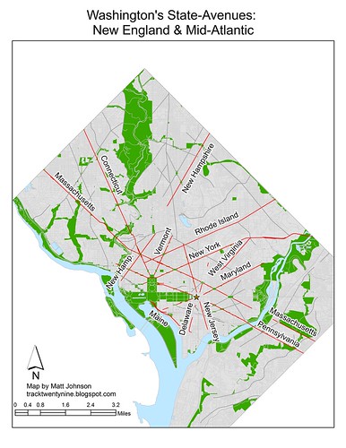
Washington's State-Named Avenues
Crossposted at Greater Greater Washington
Last week, I wrote about the system of street naming in Washington. From A Street to Verbena Street and from Half to Sixty-Third, our lettered and numbered streets make it difficult to get lost with their logical progressions.
But our transverse diagonal avenues confound everyone from tourists to suburban motorists. Not only do they break all the grid rules, they even manage to break up the grid itself in many places, like H Street, NW at New York Avenue. And to make matters worse, they often skip across parks, rivers, even entire neighborhoods, before starting up again, sometimes even on a different heading.
Locals have mostly figured out where the avenues are, at least the major ones. Maryland residents use many of these broad streets as their connections to downtown, but a short street like North Dakota Avenue goes unnoticed by almost everyone outside the immediate neighborhood.
 In fact, when the city was first established, the organized naming system extended to state-named avenues as well. It was not quite as intuitive as the numbered and lettered streets, but with only nineteen avenues, it was still easy to understand.
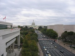
As I noted before, the plan of the city was meant to reflect the structure of the government. For that reason, the city's quadrants are centered on the Capitol Rotunda. The state-named avenues are no exception. Being the major streets of the city, L'Enfant's plan placed many of them so that they emanated from certain points. In this regard, they provided long unobstructed views toward the icons of our nascent government.
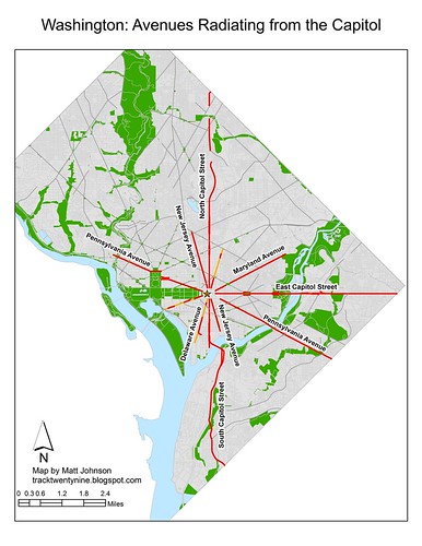 From the Capitol, North Capitol Street stretches northward, followed in a clockwise direction by Delaware Avenue, Maryland Avenue, East Capitol Street, Pennsylvania Avenue, New Jersey Avenue, South Capitol Street, Delaware Avenue, the Mall, Pennsylvania Avenue, and New Jersey Avenue.
From the White House, Sixteenth Street forms the major axis. In fact, Thomas Jefferson intended it to become the Prime Meridian, which is where Meridian Hill Park gets its name. Moving clockwise, one encounters Vermont Avenue, New York Avenue, Pennsylvania Avenue, New York Avenue, Pennsylvania Avenue, and Connecticut Avenue.
 Today, the importance of some avenues is greater than the importance of others. This is due, in large part, to their suburban connections, not any particular naming convention.
The grand avenue, home to everything from Inaugural Parades to festivals of all sorts, is Pennsylvania Avenue. Connecting the Legislative and Executive branches, it was always meant to be the heart of Washington. In the southeast, it continues as a major roadway toward central Prince George's County, Maryland.
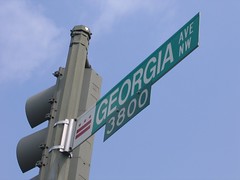
Similarly, Connecticut, Georgia, and New York all are major thoroughfares to outlying parts of the region. Another important street is Wisconsin Avenue, running from M Street in Georgetown to the Beltway north of Bethesda; it was an important road long before the name was applied. As late as 1903, it was still called the Georgetown and Rockville Pike. This historic name is the basis for two streets in suburban Montgomery County: Old Georgetown Road and Rockville Pike, the straightened version.
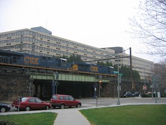 Some feel that certain states got short shrift. Tiny Delaware has a fractured, relatively unimportant street. However, the main reason that it is less important today is because of its strategic importance transportation corridor. To the north, Amtrak, MARC, and Metro's Red Line trains use Delaware Avenue to enter the L'Enfant City. Similarly, Maryland and Virginia Avenues in Southwest and Southeast now have above-grade railway embankments carrying trains along streets intended to be grand public avenues.
But street-naming doesn't have anything to do with importance to the Revolution or the prestige of any one state; at least not directly. State names were assigned to avenues based on their geographic location within the United States.
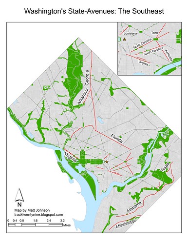
For that reason, one found Georgia Avenue in the southernmost portion of the city. Running from what is now Fort McNair across the southern side of Capitol Hill, we know it today as Potomac Avenue. Near the northern edge of the city, the avenue named after the northernmost state, New Hampshire, passed through Washington and Dupont Circles, just as it does today.
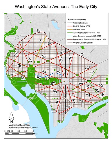 Vermont joined the union in 1791 as the fourteenth state, while Kentucky joined in 1792. It was during these years that Washington was being laid out. For that reason, they both received places within the system. Tennessee gained statehood in 1796, and its avenue became the first glaring error. After all, Tennessee forms the southern boundary of Kentucky, yet Kentucky Avenue lies entirely south of Tennessee Avenue.
By the time Congress first met here in 1800, there were three diagonal avenues left to be named. Ohio and Indiana fit into the system well enough, but Louisiana was sorely out of place.
With the first nineteen states represented in the city, Washington ran out of avenues. Maps from the 1800s available on the Library of Congress' website show that Maine and Missouri had short avenues within the bounds of the Mall, but it is unclear exactly how all the new states were represented as they came on board.
In 1890, Boundary Street was renamed after the twenty-seventh state, Florida. Despite being further south than any other state (it would remain so until 1959), it got the street forming the northern boundary of the city.
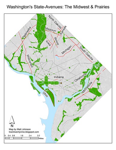
Yet by the time the twentieth century got going, Washington was expanding into the hills and dales above the Fall Line. As the street grid expanded, new avenues were added, and old ones obliterated. Around 1914, the citizens of Brightwood managed to get Brightwood Avenue renamed after Georgia. They had hoped to curry favor with senator Augustus Bacon, but he promptly died, and never had a chance to affect the fortunes of these suburban pioneers. The construction of the Federal Triangle complex in the 1930s eliminated Ohio's avenue and shortened what had been Louisiana Avenue. Louisiana's name itself had moved a few blocks east to a new street constructed as part of the changes brought by Union Station and Columbus Circle in 1907.
 Today, one can still see some geographic order to the state-named avenues. However, much of that is due to the age of certain regions. After all, New England hasn't had a new state since number twenty-three, Maine, joined in 1820. For the most part, states on the East Coast can be found downtown. Alaska Avenue is the northernmost avenue (in its entirety). Mississippi, which is at least in the south, is the southernmost state-named avenue. But the similarities largely end there.
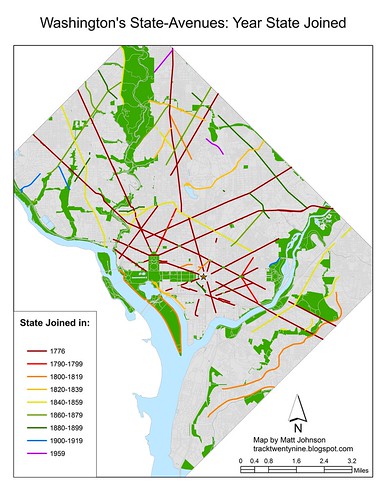

 Note: Commenting has been disabled. Please comment on this same post at Greater Greater Washington.
Monday, August 10, 2009
Passenger Flow for Individual Metro Station
Crossposted at Greater Greater Washington
In late July, I wrote about passenger flows on the Metro system. Unfortunately, the study had to cope with limitations in the data from Metro. Better data would certainly yield more informative results, we can perhaps glean some more information from the existing data. Some readers asked about breaking down the data to create flow maps for individual stations.
To estimate the ridership on each link of the Metro system, we assigned trips from each origin/destination station pair to a given route based on a survey. While the survey was unscientific, it did give us insight into how Metro riders choose their routes within the system. If we look at a given station, according to Metro's data, we can tell how many passengers are traveling to any other given station. Our model assigns those trips to certain links based on a decision tree created from the survey results. A look at this data won't tell us when the majority of riders are boarding at a given station, but it does tell us where they're going.
Take, for example, Vienna. Based on what we know about the station, it is safe to assume that most riders are boarding in the morning and traveling toward downtown. While it is clear that some of the boardings at Vienna do take place during off-peak periods and in the evening rush, with the data we have, we can't say how many.

The above map shows the passenger flow of boardings at Vienna. Most riders are going to downtown. The majority of passengers have exited by the time their train reaches L'Enfant Plaza. Few transfer to other lines.
A look at the other end of the Orange Line shows a similar trend. In this case, passengers boarding at New Carrollton have mostly alighted by the time their train gets to Farragut West. Only a few continue farther west. Similarly, not very many transfer to other lines.

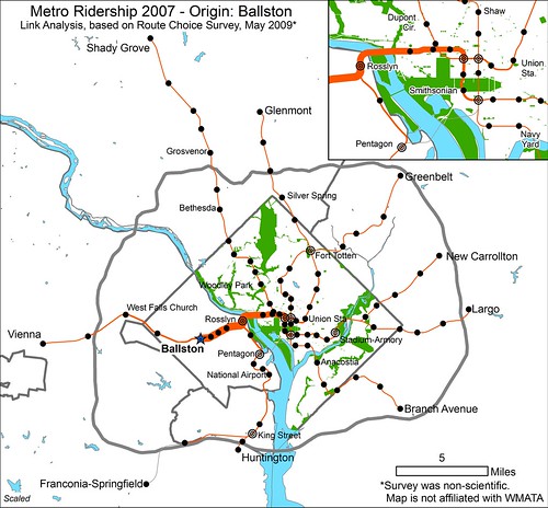
Looking at a station closer to the core, we can see that at Ballston, which has a healthy mix of offices and residential, mostly sees trips toward downtown. Remember that we can't tell when these trips are occurring, but this seems to indicate that people are either commuting from Ballston to downtown (AM) and back (PM) or from downtown to Ballston (AM) and back (PM). It seems more likely that the majority are downtown-bound in the AM. Some trips do head toward Vienna. The links west of Ballston either show people from the suburbs riding from Vienna to Ballston and back (their PM trip being captured here) or Ballstonians commuting to Vienna (AM captured here) and back, although it's actually a combination of both directions of travel.
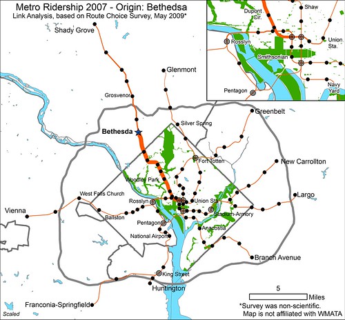
A look at a similar activity center on the Red Line, Bethesda, shows similar results. Most trips whose origin is at Bethesda are headed for downtown. Some passengers do head toward Shady Grove, however. But as before, we cannot be certain of the time of day when these trips are occurring, and therefore cannot tell for certain which the predominant direction of travel is at a given time.
A little farther down the Red Line at Cleveland Park, it appears that most trips are bound for downtown. Other urban stops of a similar nature probably show similar results.

Looking at the central business district yields some interesting results as well. Unsurprisingly, passengers bound from the Farragut Square area to destinations in Montgomery County tend to board at Farragut North while passengers bound for Virginia enter the system at Farragut West. Not as many Farragut West customers are headed toward New Carrollton and Largo as Virginia, but there is some travel to the east. Perhaps the most notable piece of information to be gleaned from these maps revolves around Green Line-bound passengers. While not many passengers bound toward Greenbelt or Branch Avenue board at either of the Farragut twins, most of those who do board at Farragut North.
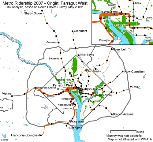
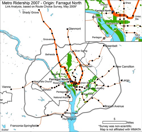
For some reason there is a preference for the Red Line for passengers headed toward the Green Line. To some degree this could be a habitual behavior remaining from the period 1993-1999 when Green Line trains from Greenbelt shared with the Red Line between Brookland and Farragut North. More likely, however, patrons probably value the Red Line's higher frequency and shorter trip to the nearest Green Line transfer station (Gallery Place). On the other hand, it could just be that more workers are concentrated at Farragut North and those headed for Orange are willing to walk to Farragut West, but Green Line riders don't see the need.
*NOTE: All maps are to scale. The thickness of the lines on each map is comparable to the thickness of the lines on all the other maps. The thicker the line, the higher the ridership.
Comments have been disabled. Please comment on this same post at Greater Greater Washington.
In late July, I wrote about passenger flows on the Metro system. Unfortunately, the study had to cope with limitations in the data from Metro. Better data would certainly yield more informative results, we can perhaps glean some more information from the existing data. Some readers asked about breaking down the data to create flow maps for individual stations.
To estimate the ridership on each link of the Metro system, we assigned trips from each origin/destination station pair to a given route based on a survey. While the survey was unscientific, it did give us insight into how Metro riders choose their routes within the system. If we look at a given station, according to Metro's data, we can tell how many passengers are traveling to any other given station. Our model assigns those trips to certain links based on a decision tree created from the survey results. A look at this data won't tell us when the majority of riders are boarding at a given station, but it does tell us where they're going.
Take, for example, Vienna. Based on what we know about the station, it is safe to assume that most riders are boarding in the morning and traveling toward downtown. While it is clear that some of the boardings at Vienna do take place during off-peak periods and in the evening rush, with the data we have, we can't say how many.
The above map shows the passenger flow of boardings at Vienna. Most riders are going to downtown. The majority of passengers have exited by the time their train reaches L'Enfant Plaza. Few transfer to other lines.
A look at the other end of the Orange Line shows a similar trend. In this case, passengers boarding at New Carrollton have mostly alighted by the time their train gets to Farragut West. Only a few continue farther west. Similarly, not very many transfer to other lines.
Looking at a station closer to the core, we can see that at Ballston, which has a healthy mix of offices and residential, mostly sees trips toward downtown. Remember that we can't tell when these trips are occurring, but this seems to indicate that people are either commuting from Ballston to downtown (AM) and back (PM) or from downtown to Ballston (AM) and back (PM). It seems more likely that the majority are downtown-bound in the AM. Some trips do head toward Vienna. The links west of Ballston either show people from the suburbs riding from Vienna to Ballston and back (their PM trip being captured here) or Ballstonians commuting to Vienna (AM captured here) and back, although it's actually a combination of both directions of travel.
A look at a similar activity center on the Red Line, Bethesda, shows similar results. Most trips whose origin is at Bethesda are headed for downtown. Some passengers do head toward Shady Grove, however. But as before, we cannot be certain of the time of day when these trips are occurring, and therefore cannot tell for certain which the predominant direction of travel is at a given time.
A little farther down the Red Line at Cleveland Park, it appears that most trips are bound for downtown. Other urban stops of a similar nature probably show similar results.
Looking at the central business district yields some interesting results as well. Unsurprisingly, passengers bound from the Farragut Square area to destinations in Montgomery County tend to board at Farragut North while passengers bound for Virginia enter the system at Farragut West. Not as many Farragut West customers are headed toward New Carrollton and Largo as Virginia, but there is some travel to the east. Perhaps the most notable piece of information to be gleaned from these maps revolves around Green Line-bound passengers. While not many passengers bound toward Greenbelt or Branch Avenue board at either of the Farragut twins, most of those who do board at Farragut North.
For some reason there is a preference for the Red Line for passengers headed toward the Green Line. To some degree this could be a habitual behavior remaining from the period 1993-1999 when Green Line trains from Greenbelt shared with the Red Line between Brookland and Farragut North. More likely, however, patrons probably value the Red Line's higher frequency and shorter trip to the nearest Green Line transfer station (Gallery Place). On the other hand, it could just be that more workers are concentrated at Farragut North and those headed for Orange are willing to walk to Farragut West, but Green Line riders don't see the need.
***
*NOTE: All maps are to scale. The thickness of the lines on each map is comparable to the thickness of the lines on all the other maps. The thicker the line, the higher the ridership.
Comments have been disabled. Please comment on this same post at Greater Greater Washington.
Friday, August 7, 2009
Washington Streets
 Crossposted at Greater Greater Washington
 Visitors and residents of Washington, DC know, to one degree or another, about the city's street naming conventions. Most tourists know that we have lettered and numbered streets. And to some degree, they know there is a system, but it doesn't stop them asking us directions. But most out-of-towners and even many residents don't understand the full ingenuity of the District's naming system.
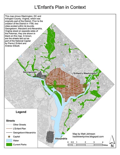
Washington is partially a planned city. The area north of the Potomac and Anacostia Rivers and south of Florida Avenue (originally Boundary Street) is known as the L'Enfant City. This area of Washington was the original city of Washington, laid out by Pierre L'Enfant and Andrew Ellicott. It is comprised of a rectilinear grid with a set of transverse diagonal avenues superimposed. Avenues frequently intersect in circles or squares, and the diagonals create many triangular or bow tie-shaped parks.
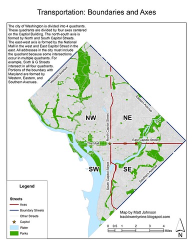
 Washington is the seat of government of a nation. Believing that the structure of the government should inform the structure of the city, L'Enfant centered the nascent city on the Capitol, home of the Legislative (and at the time, the Judicial) branch of the government, the one the framers held in highest esteem. From this great building radiate the axes of Washington. North and South Capitol Streets form the north-south axis; East Capitol Street and the National Mall form the east-west axis. These axes divide the quadrants.
The axes also provide the basis for the naming and numbering systems. Lettered streets increase alphabetically as they increase in distance both north and south of the Mall and East Capitol Street. Numbered streets increase in number as they increase in distance both east and west of North and South Capitol Streets.
Many street names intersect in multiple quadrants. G Street intersects Sixth Street in all four quadrants, and each of these intersections is separated by over a mile. Western, Eastern, and Southern Avenues form in many places the land boundaries of the District.
 North of Georgetown and Boundary Street (Florida Avenue), the area formerly known as Washington County, DC began to develop. For the most part, developers extended the grid as the most efficient way expand the growing city. Some areas, notably Petworth, recreated the principles of the L'Enfant plan, with avenues and circles intersecting the grid. In other places, geography made a rectilinear grid impractical.
As the city expanded, so did the system of naming streets. In the L'Enfant city, the highest lettered street was W Street (running between Ninth and Fifteenth Streets NW). Unlike numbers, the alphabet is not infinitely expandable. In order to continue to have an alphabetical progression of streets, the alphabet starts over. Only "streets" are subject to the convention. Avenues, roads, drives, and other minor streets do not conform to the alphabetical progression. "Places," on the other hand, usually appear one block north of the correspondingly lettered street and often share the same first letter.
After the first alphabet runs out of letters, street names restart alphabetically with two-syllable names. "Adams Street" follows "W Street." Once the second alphabet is exhausted, the system repeats with words of three syllables. "Webster Street" is followed by the third alphabet's "Allison Street." However, the Fourth Alphabet does not use words of four syllables. Instead, the Fourth Alphabet, only present in the Northwest and largest quadrant, uses the names of plants in increasing alphabetical order. Thus "Aspen" follows "Whittier."
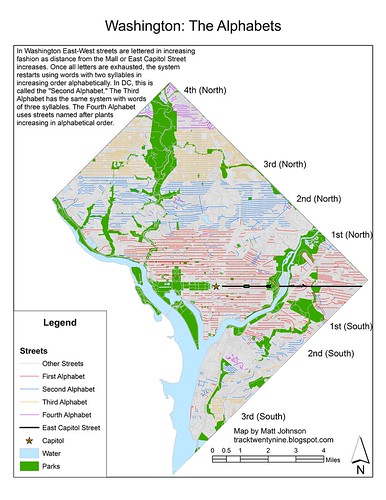 Typically, each of the other alphabets uses the same letters used by the First Alphabet (A-W, skipping J). However, there are some exceptions. The Second Alphabet has Yuma Street, there's a Jefferson Street in the Third Alphabet, and Xenia Street appears in Southeast. East-west streets in the District are often discontinuous due to obstructions. Sometimes the street continues with the same name on the other side, and sometimes it changes to a different name. Shepherd Street NW, for instance, is split by Piney Branch Park between Fourteenth and Sixteenth Streets, but keeps the same name on both sides. However, on the other side of Rock Creek Park, in Upper Northwest, the two-syllable "S" street name is Sedgwick. Still, a look at the first letter of streets in the District easily shows the strata of the alphabets.
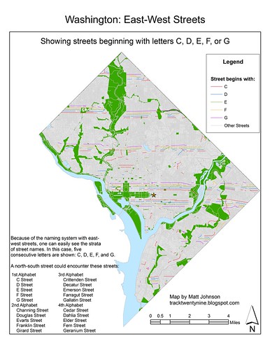 The highest numbered street in the District is 63rd Street in the Capitol Heights section of Northeast. Southeast's nearby 58th Street is that quadrant's highest numbered street. In Northwest the ridges and valleys of the Potomac Valley cause numbered streets (and the grid) to give up the ghost at 52nd Street. And tiny Southwest sees its highest number with 23rd Street south of the Lincoln Memorial.
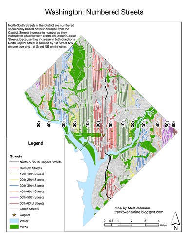 Of course, without its state-named avenues, Washington would have a far less complex street system. But the avenues don't only add complexity, they also close the streetscape, provide vistas to monumental buildings, and create squares, plazas, and parks throughout the city. These famous streets are important streets in the city, but they don't conform to the system, and as a result are more difficult to find.
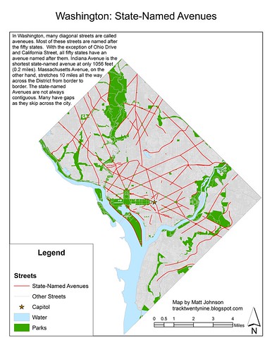
Except for California Street and Ohio Drive, all the states have avenues named after them. The shortest of the avenues is Indiana Avenue, found near Judiciary Square and the Archives. It stretches less than half a mile, exclusively in Northwest. While no state-named avenue passes through all four quadrants, the longest, Massachusetts Avenue, passes through three. It stretches from border to border across the District, although it lacks a bridge over the Anacostia, and continues northward into Montgomery County, Maryland.
 Commenting here has been disabled. Please leave comments at this same post on Greater Greater Washington.
Urban Thinking
Planetizen is trying to figure out who the top urban thinkers are. If you'd like to vote or nominate your own favorite, check it out: Planetizen.
Subscribe to:
Posts (Atom)


