Showing posts with label Biking. Show all posts

Wednesday, September 29, 2010

See planning history in Greenbelt by bike

When it comes to the built environment, the Washington region has long been one of the proving grounds for Planning.

From the first-ever National Planning Conference in 1909 to the demonstration of New Urbanism at Kentlands, Washington has benefited from planning ideas that often seemed far-fetched at the time.

Greenbelt, Maryland is no exception. It’s the best-preserved example of New Deal-era utopian town planning in the United States, and has been named a National Planning Landmark. This Saturday, I’m leading a bike tour of the community (details below). I hope you can make it.

About Greenbelt:
Faced with housing shortages, a decimated economy, and deteriorating conditions in cities, the Roosevelt Administration, as a part of the New Deal, set out to build 4 “greenbelt towns” as an example of how suburban development could and should move forward.

Partially inspired by England’s garden city movement, Greenbelt was intended to be a self-contained community surrounded by a green belt of parks, forests, and farms. Today, Greenbelt is not as isolated, but the historic center maintains its park-like setting.

Planning of the town was holistic, in keeping with the principles of the New Deal. In addition to housing, a commercial center was constructed. Civic buildings included an elementary school/community center and recreational buildings.

Perhaps most unique in the design was that residential buildings were turned “inside-out”. Residential structures have their main entrances on the “garden side.” The design of the community meant that pedestrian paths wound through superblocks, where buildings were turned inward toward parks, gardens, and social interaction. At the rear of the units is the street, the so-called “service side.”

Much of the architecture in the community is based on the International style with Art Deco elements. Some elements which are now becoming more common in urban design have been present in Greenbelt for over 7 decades. One example is the “shopping court” at the Roosevelt Center, where shops front on a pedestrian plaza, and parking is in the rear.

Greenbelt was designed with the automobile in mind, but it was not designed for the automobile. I think this is the largest and most crucial difference between Greenbelt and the prototypical post-war suburb. The community is walkable, traffic is calm, and despite being surrounded by sprawl, cars do not dominate the landscape.

The greenbelt towns were intended to be prototypes for suburban development. But the experiment didn’t become typical of suburbia. It did, however, help to inspire several planned communities, including Reston in Virginia, and Columbia and Montgomery Village in Maryland.

The Tour:
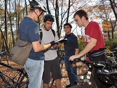
This Saturday, October 2, I’ll be leading a bike tour of the community. The tour will be approximately 4 miles in length and will include a tour of the Greenbelt Museum. It will cost $5.

The tour will begin and end at the Greenbelt Metro station. It starts at 1pm and will be complete by 5pm.

If you’re interested in attending or have questions, please email me at mcjohnson@ggwash.org.

Top photo by M.V. Jantzen on Flickr.

Thursday, June 3, 2010

Park Police take the wrong approach to safety

Besides closing park bike paths at dark for the "safety" of cyclists, the Montgomery County Park Police have taken another interesting approach to promoting cyclist and pedestrian safety.

This mobile variable message display board has been placed directly on the Sligo Creek Trail near Silver Spring. It's message: "Drive Safely / Crosswalk Ahead / Share the Road." Well, we wouldn't have to share the road if Park Police didn't block the trail with a sign, now would we?

Of course, as a cyclist, I appreciate that the Park Police are encouraging drivers to be on their best behavior. Their hearts are in the right place, but their effort is a bit - ah - misplaced.

Sunday, March 28, 2010

Highways After People

On Sunday, I had the opportunity to travel to Breezewood, Pennsylvania to bike on a portion of the Abandoned Pennsylvania Turnpike. Check out my photos below.


This stretch of the abandoned turnpike is 13 miles long, and was abandoned in 1968. It includes two tunnels, Rays Hill and Sideling Hill. I had hoped to bike the whole segment, but rain set in, and the trip had to be cut short.

So, the trip only included a ride through the Sideling Hill Tunnel, 1.3 miles of inky darkness.

This section of the Turnpike opened in 1940, and was bypassed in 1968 because it was cheaper than twinning the two tunnels. It's an eerie site. It's out in the middle of nowhere, and seems some remnant of a post-apocalyptic world. The whole time we spent on the old turnpike, we saw only two other people, local teens by the look, emerging from the darkness on foot.

The tunnels actually date back to 1881 and the construction of the South Penn Railroad, which went bust before completion. In the late 1930s, the Pennsylvania Turnpike Commission completed and expanded the tunnels.

However, most of the railroad line follows a different alignment from the Turnpike. In places, you can see traces. Several photos in my set show the railroad grade (and a culvert) just west of the western portal of the Sideling Hill Tunnel.

Monday, March 22, 2010

Downtown bike lane proposal needs fixes at the ends

Crossposted at Greater Greater Washington

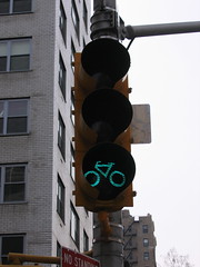
NYC Bike SignalLast week, DDOT announced a plan for a set of cutting-edge bike facilities downtown, but the plan does raise some issues. The plan will dramatically improve cycling conditions downtown, but some of the constraints on the plan may call for even more innovative solutions.

One of the concerns voiced at Thursday's meeting was about what happens to the bike lanes on I (Eye) and L Streets when they end at the diagonal avenues (Pennsylvania Avenue at the west end of I, Massachusetts Avenue at the east end of L).

Because the bike lanes run on the left side of the east-west streets, cyclists will either be expected to turn into the left lanes of Pennsylvania and Massachusetts Avenues or find some other way of crossing several lanes of traffic to get to the right curb.

More->

*Note: Commenting has been disabled. Please continue the discussion at Greater Greater Washington.

Friday, March 27, 2009

Bike Improvements: 9th Ave Cycle Track

Yesterday, I talked about my visit to the remade Madison Square. Also during my visit to New York, I took time to view the bicycle improvements along Ninth Avenue. These improvements have made biking along the major north-south artery safer by separating bikes from auto traffic. This project was another great improvement made by the NYC DOT under the leadership of Janette Sadik-Kahn

The Ninth Avenue Cycle Track runs from 31st Street southbound to 16th Street. Along the way, it is along the left curb of the street. It is divided from traffic by parked cars, bollards, and, at intersections, concrete islands. 


Cyclists are protected from left turns by protected left arrows at intersections. Cyclists have their own signals, which are synced with southbound through signals on Ninth Avenue. When left-turning traffic has a green arrow, cyclists are faced with a red "cycle" signal. 

Again, it seems that New York City is taking the lead in providing the street as public space for all users. Here in DC, the District Department of Transportation plans to implement a cycle track on Fifteenth Street NW. Under the reconfiguration proposal, 15th Street will be reconfigured between Massachusetts Avenue and Florida Avenue to include three northbound car lanes, one northbound bike lane (between the right-most northbound lane and the parking lane), a parking lane on each side of the street, and a southbound cycle track between the left-side parking lane and the western sidewalk. It will be separated from parked cars by a raised curb and will include north-facing signals for southbound cyclists.

Thursday, August 14, 2008

Why so Hurrious?

As I've pointed out before, one of the main reasons for my move back into the city was because I missed biking. As such, my trips to the grocery store are much easier, and my commute to the office is shorter by bike than by Metro (but only by about 5 minutes).

And now that I've once again become a bike commuter, I really have to wonder: why so hurrious?

I used to bike commute between my apartment in the Home Park neighborhood in Atlanta to my office across from Hurt Park downtown, a distance of 3 miles. My new commute takes me from North Columbia Heights to NoMa, a shade over 4 miles.

And while DC is more bike friendly than Atlanta, it's drivers aren't. I love the fact that DC has a network of bike lanes and trails. The city is also flatter and has a great street network. But the drivers here are very aggressive.

I suppose that traffic seemed tamer in Atlanta because the freeway network was mostly completed. So the suburban traffic doesn't have to race through neighborhoods just to get to the I-75/85 Raceway. Also, because Atlanta was never planned to be a grand capital, many streets are narrow and frequently congested.

But what's the rush anyway? It seems to me that people are in far too much of a hurry these days. They can't wait for me to clear an intersection before turning, they whiz by with mere inches to spare, and they gun their engines as they pass--as if to demonstrate their superiority.

Perhaps these motorists are just insecure. They are ashamed of themselves, perhaps? They race out of traffic lights like horses out of the gate at the Kentucky Derby only to have a bicycle--a bicycle--catch them at the next light. Perhaps they regret the expense of their Ford Enormous and wish they too had the ability to cycle to work.

Perhaps they're just rude or ignorant of the law.

They wouldn't be alone in that, though. According to the WashCycle, recently an MPD (DC) officer followed an injured bicyclist to the hospital to give him a ticket for riding on the sidewalk after being struck by a right-turning vehicle on Independence Avenue. Biking on the sidewalk isn't even illegal in the District (except in the CBD).

If the cops don't even know the rules, why should we expect motorists to? And let's not forget that in DC, bicyclists have to know three sets of laws (DC, MD, VA) regarding bicycles.

But education aside, we'd all be a little better off if drivers (and bicyclists) just calmed down and took it easy. We need to respect our fellow road users and remember that we all have a right to use the transportation infrastructure.

And drivers: before you intimidate a bicyclist, remember that that's one less driver to congest your route. And even if we're slow-moving, we're usually at least as fast as you in an urban area, and we'll be out of your way as soon as possible.

Friday, July 18, 2008

Moving on Up to the D-C(ide)

After a year of living in the suburbs, I'm finally moving back to the city. I'm excited. Tomorrow, I move into a nice North Columbia Heights rowhouse with two of my fellow UM Planning students.

I grew up in a rural community in North Georgia, but I spent four years living in central city Atlanta. When I moved to Metropolitan Washington, I ended up in a nice Hyattsville apartment. And while the view is certainly nice, I just wasn't cut out for suburban living.

As a person who has liberated himself from the car culture, I found it much too difficult to get around out here in "the sticks." Okay, so maybe I'm exaggerating--Hyattsville isn't really the sticks, but it's not exactly cosmopolitan either. And yes, they do roll up the sidewalks here--around 9 o'clock.


So I'm happy to be moving to the District. One of the things I missed most during my year of exile was (is?) biking. When I was living in Atlanta, I biked everywhere. Over the last year, I've only managed to take the steed out for weekends on the region's trails (and an exciting 50-States bike tour).

Another exciting aspect of my new pad is the access to the park. Rock Creek Park (actually a branch thereof) is just at the end of my street. As I've pointed out before, I think this park is one of Washington's greatest assets, although there is certainly room for improvement.

*Note: Due to the move, posting may be disrupted for some time. If the cable guy shows up as scheduled, I'll have internet on Tuesday. If not, your guess is as good as mine.

Sunday, September 16, 2007

"Mass Ave Traffic Keep Left"

Well, I have finished my 50 States Bike Ride with the completion of phase three. I only had three states left, and I almost tried to complete them on Wednesday, but Southeast is not such a good neighborhood and it was getting dark. Anyway, I am done, and after 67.25 miles, I am ready for a rest.


I rode two short rides today, totalling almost 25 miles. One of my rides (the red one on the map, starting lower-right, moving northwest) highlighted my new favorite street in DC. Massachusetts Avenue stretches from Maryland to the Anacostia (and actually continues on the other side into Southeast) and is a marvelous street for bike riding. It is the avenue created by L'Enfant to complement Pennsylvania Avenue; it is the same width (160 feet) and it is actually the longest street in the District. It is home to many embassies and is the northern boundary of "Downtown Washington." From American University (home to my new NPR affiliate) to Union Station, this thoroughfare makes for a thorough cross-section of the cityscape. Anyway, my favorite section is from its intersection with Cathederal Ave in Northwest to 17th Street in Southeast. Starting near the Washington Cathederal, it is a steep downhill all the way to Rock Creek, allowing me to pick up quite a bit of speed on my bike. The next best thing is the trip around all of L'Enfant's obstacles. First there is quiet Sheridan Circle, bustling Dupont Circle, busy Scott Circle, crowded Thomas Circle, rebounding Mount Vernon Square, beautiful Columbus (semi) Circle, serene Stanton Park (square), and finally, quaint Lincoln Park (square). I love the circles and squares because of the sloloming. Mass Ave is fairly flat after Sheridan Circle, but getting to the high starting point at Cathederal Ave requires a bit of steep climbing.

Anyway, I don't know why that Sydney Ellen Wade character from "The American President" has such a penchant for getting lost on Dupont Circle. It's actually pretty easy to navigate. Connecticut Ave has an underpass, so only traffic travelling to the circle has to enter it; Massachusetts Ave has express lanes (which cross into the cirle, make no stops, and cross back over on the other side); and that leaves only P Street NW, 19 Street NW, and New Hampshire Ave. Personally, I love going to Dupont Circle. Other than being the heart of Washington's gay scene, it's always busy with office workers, apartment dwellers, and those damn lost tourists (just go around again nitwit). I must say that whoever programs the traffic lights here in DC has done a bang-up job. Imagine coordinating the lights on Dupont Circle alone. Wow!
View Larger Map

Thursday, September 13, 2007

You've Got Tan Lines WHERE?

Almost forgot, I'm putting up a link to a map of my bike trips so far this week (Sunday included). Anyway, all this biking has given me a good bit of sun, and believe it or not, I've gotten three new tan lines: One across each of my wrists (because I wear gloves when riding) and one across the top of my forehead (from my helmet). It'll be okay; as the tan fades a little, it won't be so obvious. I almost fell out of my chair when I noticed my wrists.


View Larger Map

KEY:
  • The GREEN line is day 1 of my 50 States Ride (Monday). It starts at the green dot-thinggy, goes to the northeast, then loops back south, goes through Washington, and ends near the red dot-thinggy. [[22.48 MILES]]
  • The RED line is part one of day 2 of my 50 States Ride (Wednesday, noon-4:30). It starts at the red dot-thinggy and goes north, west, then south again. It ends at the blue dot-thinggy, where I had dinner. [[29.17 MILES]]
  • The BLUE line is part two of day 2 of my 50 States Ride (Wednesday, 5:30-7:00). It starts at the blue dot-thinggy and goes southeast down Conn. Ave to Mass. Ave, then across the Anacostia River. It ends near the Anacostia Naval Station. [[9.54 MILES]]
  • The ORANGE line is the ride I did this suday with other people from the DC area GT alumni association. It starts at the YELLOW dot-thinggy (because Google Maps doesn't have an orange one). [[27.28 MILES]]
  • The PURPLE line is not from this week. I did it last week, and it starts at the purple dot-thinggy. It goes east, then loops around East Potomac Park, then north to Columbia Heights. [[17.06 MILES]]
  • The RED BED at the upper right is my apartment. So now you know why I want to move to the District as soon as possible. I am far out into the 'burbs.
  • The GREEN SCHOOL, also in the upper right, is the University of Maryland.

Wednesday, September 12, 2007

Ride Like the Wind

Okay, so maybe I didn't ride like the wind today, but I was going pretty fast down Connecticut past the Zoo this afternoon. My class was cancelled today, so I was free for a day or so and I decided to put phase 2 of my 50 States Ride into effect. Anyway, not alot to say that the pics below can't so I'll keep it brief.

Today's ride was more eventful than Monday's though. (It was longer too, almost 39 miles). Just after I got off of Arizona Ave NW, I am biking up that goddamn mountain near American University and this college-aged teenager comes walking down the street sobbing vocally. I'm pretty sure I heard the words "please God" and "library" interspersed in there several times. He even had blood on his shirt, like from a nosebleed. Wierd!

I also saw the same guy twice in different parts of the city. I'm biking west on Aspen Street, near Georgia Ave and this Toyota hybrid car drives by me eastbound, so I got a good look at the driver; older man gray hair, balding, and a mustache. I only noticed because I was thinking 'I'm glad that car is going the other way, because there is NO way I could hear it behind me.' So anyway, like two hours later (maybe more) I'm going northbound on Idaho Ave, and this Toyota hybrid passes me (didn't hear it either). Anyway, it turns onto Newark Street NW in front of me, and I do the same. And as I pull up next to it at the Wisconsin Ave light, I look over and IT'S THE SAME GUY. We're like across town here! What's he doing over here? Did he like follow me with his silent car or something? WIERD!

Anyway, I'll let you get on with your perusing. Three left: Alabama, Mississippi, and Texas!


Tuesday, September 11, 2007

Around the District in 80 Days

Ok, so it hasn't been 80 days; as a matter of fact, I've only been going at it for about 4 hours; but then I'm only halfway done. I saw quite a bit of the district this morning during my 25 mile bike ride. I took some photos too; since they're worth several thousand words, I'll shut up. Phase I of my 50 states bike ride is complete!